
Implementation of Albertine masterplan to cost sh150b
According to the plan, all towns in the Albertine region, whether small or big, will have designated residential areas, business centres, bus terminals, schools, agricultural and industrial zones, among others.
OIL | GAS
The oil and gas activities are expected to lead to population explosion in the Albertine region. This will have challenges on the region, including encroachment on protected areas, growth of unplanned settlements and misuse of land deemed good for agriculture.
As part of measures to combat the potential challenges, the Government developed the Albertine plan, which is currently under implementation, writes Martin Kitubi.
Implementation of the Physical Development Plan (PDP) for the Albertine Graben is underway, authorities have revealed.
A five-year budget of sh150b is needed by the Ministry of Lands, Housing and Urban Development for the plan.
In an interview, Denis Kidega, a senior physical planner with the lands ministry, said: "We are preparing for oil and gas activities. As the lands ministry, we are required to cater for development of the country."
If not well planned, he said, the Albertine region will turn into a slum, which is a health hazard to any developing country.
At the moment, he said, a number of roads in the region are being expanded or tarmacked as the Government prepares for the development stage of the oil and gas sector.
In addition, physical development plans for some towns in the area are ready for implementation by local governments.
Towns whose physical plans are ready are Wanseko and Biiso in Buliisa district, Kigorobya, Kiziranfumbi, Kyangwali, Kabwoya, Butema, Kyarushesha and Buhuka in Hoima district.
The above towns are near to the different oil and gas infrastructure development areas and, therefore, will attract more population.
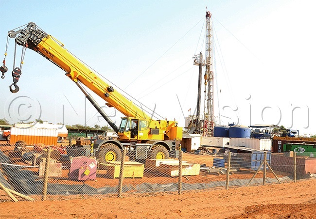 Kigogoro drilling site in Bugongu sub-county, Bulisa district. Buliisa is among the priority districts in the masterplan
Kidega made the remarks just after the Second National Content Conference organised by the Petroleum Authority of Uganda (PAU).
The conference, which attracted hundreds of oil and gas suppliers, was based on the theme, Linkages between Oil and Gas and other sectors of Uganda's Economy.
The two-day conference in Kampala last month, was aimed at discussing opportunities and challenges in the sectors that will benefit from the oil and gas sub-sector.
Ernest Rubondo, the executive director of PAU, said: "Oil and gas activities are going to change a lot in the country. These plans are developed to prepare us for the future. If we do not plan, the region will be flooded with slums, which is not good."
BREAKDOWN OF NEEDED FUNDS
However, all these activities will come at a cost. As part of the implementation, Uganda received financial support from the World Bank to undertake preparation of the plan.
According to the physical development plan, $44m (about sh150.7b) will be needed by the lands ministry to implement all its activities.
The budget estimates include $24m (about sh90.4) for planning and capacity building, and an additional $20m (about sh75.3b) to complete the ministerial zonal office, land surveying and titling for the Albertine region.
According to the plan, the Final Albertine Graben Physical Development Plan will be completed following incorporation of comments from another round of Albertine and Kampala stakeholder participation sessions.
SERVICES TO BE OFFERED IN DISTRICTS
The districts have been divided into clusters, according to services to be offered.
These include northern region of the Albertine covering Nwoya to Moyo districts and the central region covering districts in the oil-rich areas.
The other is called the southern region, covering Kabarole to Kanungu.
The northern region will be mainly for agriculture, tourism and trade. The central region will serve agriculture, oil and gas development sectors.
Just like the northern region, the southern, too, will be for agriculture, tourism and trade.
There are over 30 districts in the Albertine, region. They include Kisoro, Kabale, Kanungu and Rukungiri, Bushenyi, Sheema, Ibanda, Ntungamo and Mitooma in Ankole.
It also includes Kamwenge, Kyenjojo, Notoroko, Kasese, Bundibugyo and Kabarole in the Rwenzori region, Kibaale, Hoima, Kikuube, Masindi, Buliisa and Kiryandongo in Bunyoro.
The plan also covers Nebbi, Pakwach, Zombo, Arua, Maracha, Koboko, Yumbe, Adjumani and Moyo districts in the West Nile. It will also cover Nwoya and Amuru in the Acholi sub-region.
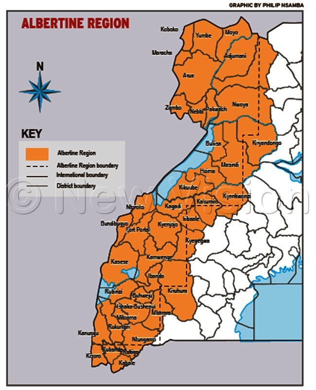
PRIORITISED DISTRICTS
The priority districts are in five major categories. The first include Hoima and Buliisa. These will serve as top priority centres for the rapid developing oil and gas industry.
The two districts will be home to industry facilities, infrastructure, impacted urban development (residential, commercial, industrial), environmental management and resettlement among others.
These will be followed by seven districts in the second category. These are Nebbi, Kabarole, Kyenjojo, Kasese, Bushenyi, Sheema and Ntungamo districts.
According to the masterplan, Nebbi will be a priority to accommodate new rail and multimodal transport and related industry.
The other six will serve as priority agroprocessing, forestry and tourism zones.
However, increased industrialisation, agro and mineral processing will be done in Bushenyi, Sheema and Ntungamo districts.
The third category includes 10 priority districts. These include Masindi, Kibaale, Ntoroko, Bundibugyo, Mitooma, Rukungiri, Kanunga, Kisoro, Kabale and Arua.
Masindi will serve as a hub for agro-processing.
Whereas Ntoroko and Bundibugyo will serve as hubs for gas-production, cross-border trade and immigration with eastern DR Congo, tourism and marine transport, Kisoro and Kabale will be for mining, tourism and mini-hydro power generation.
Arua will handle trading, transport, and agro-processing.
Category four has eight districts which include Koboko, Yumbe, Moyo, Adjumani, Kyankwanzi, Kibaale, Kamwenge and Rubirizi. These will focus on trade.
Category five will have Nwoya, Amuru, Kyankwanzi, Ibanda and Buhweju.
Although both category four and five are as important as the others, they will be considered once the Government raises more funds.
SPECIAL DEVELOPMENT ZONE
The Government has also selected some areas to serve as "special planning area" development zones. These include Arua-Vurra, Pakwach- Nebbi-Goli, Hoima-Kabaale, and Ishaka- Bushenyi-Mbarara-Ntungamo zones.
Arua-Vurra will serve as a transport, cross-border trade and agro-processing centre once additional power resources reach the area and when rail transport is extended from Nebbi.
Pakwach-Nebbi-Goli will become a major multi-modal transportation hub, agro-processing, fishing centre as rail connection is completed from Tororo.
Hoima-Kabaale zone will be the centre of the oil and gas industry.
According to the masterplan, the zone will have rapid developing oil infrastructure such as the oil refinery, pipelines, power generation, offices, support services/industries, and upgraded roads.
The zone will also have resettlement and a growing population with related social and economic facilities required and that the zone will need to be prioritised for that purpose.
Ishaka-Bushenyi-Mbarara-Ntungamo zone will be an important agro-processing and future mineral production/processing zone along with social facilities and Northern Corridor transport links from Burundi and Rwanda through to Kenya and beyond.
RATIONALE OF THE PLAN
According to the document, the development of Albertine physical plan was guided by Vision 2040 and the National Development Plan.
The main objective of the plan is to "provide a physical development planning framework to promote and guide the development process in the Albertine Graben region in a sustainable manner through the preparation of a 25-year integrated physical development plan."
As a result, the lands ministry has declared the Albertine region as a special planning area, following the oil and gas discoveries.
This is so because the region has Uganda's sensitive areas with several protected areas such as lakes, rivers, wetlands and national parks.
The region is also home to several cultural sites that need to be preserved.
The Albertine region, the plan says, includes 25% (68,000km2) of Uganda's land, 25% of national population and produces 30% of the nation's food needs.
The region also accounts for over 70% of the country's tourism revenue and contains about 3.5 billion barrels of oil destined to boost Uganda's economy for the next 25 years and beyond. It will also host unique and delicate oil and gas infrastructure.
In addition, the region shares borders with two unstable neighbours; and is now centre to Uganda's emerging petroleum industry.
The region, therefore, comes with a complex mix of development issues, opportunities and constraints.
The masterplan addresses these issues and seeks a structured solution.
 Hoima and Buliisa districts will be home to industry facilities and infrastructure
PROJECTED COSTS
According to the physical development plan, $44m (about sh150.7b) will be needed by the lands ministry to implement the plan.
The budget estimates include $24m (about sh90.4) for planning and capacity building and an additional $20m (about sh75.3b) to complete the ministerial zonal office, work on land surveying and titling for the Albertine region.
STRICT REGULATIONS
The masterplan says all structures will be required to have approved plans from local government authorities at a fee.
The fee, just like other areas, mainly urban centres, will vary depending on the type of structure to be set up, for instance, school, hospital, shopping mall or a hotel.
According to the plan, all towns in the Albertine region, whether small or big, will have designated residential areas, business centres, bus terminals, schools, agricultural and industrial zones, among others.
Under the plan, all the district local governments will be required to monitor the construction of any structure in their jurisdictions.
Those deemed below standards, the plan says, will either be demolished or construction will be halted by authorities.
The arrangement, according to the plan, will affect both existing and new structures.